A full range of specialised survey services delivered by accredited topographical surveyors — designed to give your project the accurate data it needs to succeed.
A topographical survey — also called a topo survey or topographic land survey — is the foundation of almost every land or property development project. At Surveyor Topographer, our team undertakes topographic surveys that capture every relevant natural and man-made feature of your site, at a level of detail matched precisely to your project needs.
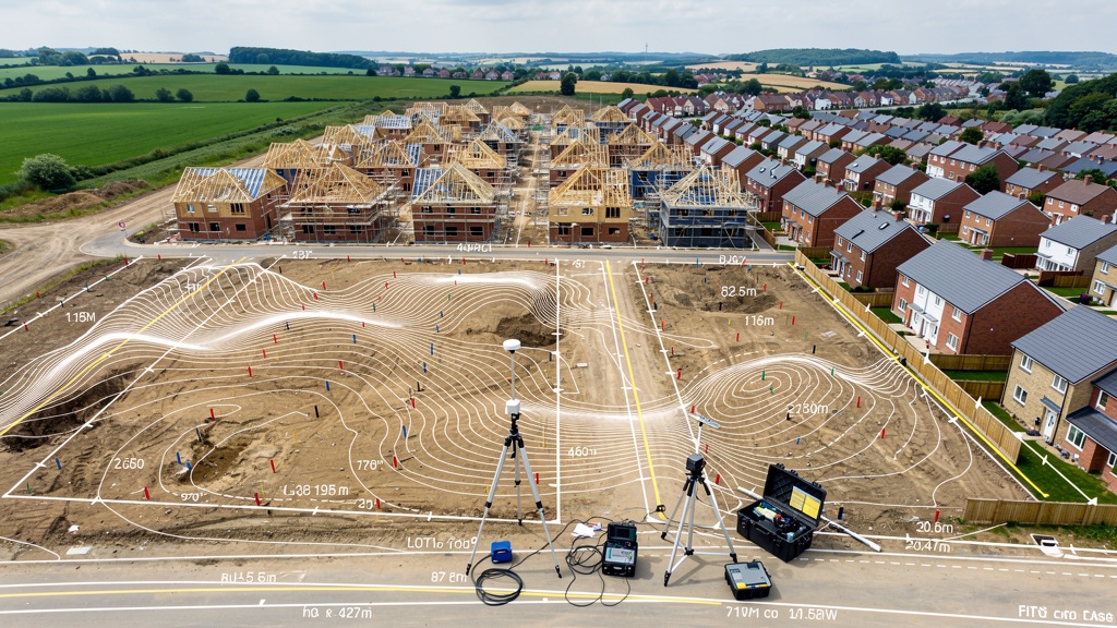
We use total station and GPS equipment to record precise grid and datum-referenced data points across the area of land. The resulting topographic survey will provide you and your design team with accurate land level data, contour lines, feature positions, tree surveys and much more — all in your chosen CAD format.
Whether you're an architect designing a house extension, a planner assessing a greenfield site or a developer undertaking land development feasibility, an accurate topographic survey is the single most important document you can have.
Want to learn more? Read our plain-English guide to topographical surveys, our guide to topographic surveys for planning permission and our guide for architects.
Our 3D laser scanners capture millions of precise data points in a single sweep, creating a highly detailed three-dimensional model of any structure or landscape. This technology is transforming the way architects, engineers and heritage specialists work — and Surveyor Topographer is at the forefront of its application in the UK.
3D laser scanning is the ideal solution when conventional survey methods cannot capture the required level of detail, or when the complexity of a structure means physical measurement would take too long or introduce too much error. The resulting point cloud data is directly importable into Revit, AutoCAD, Rhino and all major BIM platforms.
Further reading: our complete guide to 3D laser scanning for buildings and land surveys.
A measured survey of an existing building provides your architect or designer with accurate floor plans, elevations and sections — essential for renovation, extension or change-of-use projects. Our team produces detailed drawings of every space, capturing all relevant features to a specified level of detail.
Surveyor Topographer's measured survey service combines traditional measured survey techniques with modern 3D laser scanning where appropriate — giving you the accuracy you need without unnecessary cost. All drawings are delivered in AutoCAD DWG format, referenced to Ordnance Survey datum.
Get a Measured Survey QuoteFurther reading: what is a measured building survey? Our complete guide.
An accurate flood risk assessment is increasingly required by local authorities as part of planning applications in England and Wales. It starts with reliable, accurate land level data — and that means a high-quality topographic survey.
Our flood risk assessment surveys capture the precise levels needed to model surface water flow, assess flood risk zones and demonstrate compliance with national planning policy. We work closely with hydrologists and drainage engineers, providing the accurate data they need to complete their assessments confidently.
Further reading: why your flood risk assessment starts with a topographic survey.
Unresolved boundary issues are one of the most stressful — and costly — problems a property owner can face. Our boundary survey service provides precise, legally defensible land measurements that clarify exactly where your boundary lies, helping to resolve disputes and protect your property rights.
Where required for HM Land Registry title plans, we produce surveys in the correct format for submission. Our team is experienced in advising on land and property boundary matters in collaboration with solicitors and planning consultants.
Get a Boundary Survey QuoteFurther reading: how boundary dispute surveys help resolve property disputes.
Every successful construction project begins with a solid base of accurate survey data. Our construction survey service supports projects from initial feasibility through to setting out and as-built verification — providing the reliable data your team needs at every stage.
We understand the pressures of construction programmes, which is why we prioritise speed without sacrificing accuracy. Our surveyors are experienced in working on live construction sites and will always co-ordinate with your site manager to minimise disruption.
Further reading: our guide to construction surveys: setting out, as-built and monitoring.
All Surveyor Topographer survey deliverables are produced as industry-standard CAD drawings, georeferenced to the Ordnance Survey National Grid and datum (typically Newlyn datum for levels). This means your survey data integrates seamlessly with OS mapping, land registry plans and your design team's existing CAD environment.
We can supply data in AutoCAD DWG, DXF, PDF, GeoTIFF and a range of GIS formats. Our standard survey specification includes full feature coding, layer management and annotation to the conventions most commonly used by UK architects and engineers.
Discuss Your Data RequirementsFurther reading: Ordnance Survey vs topographic survey — what's the difference?
The type of survey you need will depend on the purpose of the survey and your project stage. For most planning applications and design projects, a topographical survey is the starting point. If your project involves an existing building, you'll also need a measured building survey. We're happy to advise — contact us for a free consultation.
Yes — we regularly combine topographic surveys and tree surveys as part of the same site visit. This is more cost-effective and ensures that tree positions are accurately co-ordinated with the wider survey data. We record tree positions, crown spreads, heights and species, ready for use in arboricultural impact assessments and planning submissions.
The level of detail in our surveys is agreed with you as part of the written specification before work begins. Standard topographic surveys include all visible features above and below ground (within reason). We follow a specification format based on the RICS Geomatics guidance note for measured surveys, adapted to your specific project requirements.
Absolutely. We regularly undertake surveys of large areas of land — from multi-hectare greenfield sites to whole farm holdings. For very large areas, we may combine terrestrial surveying with drone photogrammetry to maximise efficiency without compromising the accuracy of the final data. Our team has the resources and equipment to scale up for large projects at short notice.
Unsure which service you need? Our accredited topographical surveyors are happy to advise. Fill in the form and we'll be in touch within one working day.