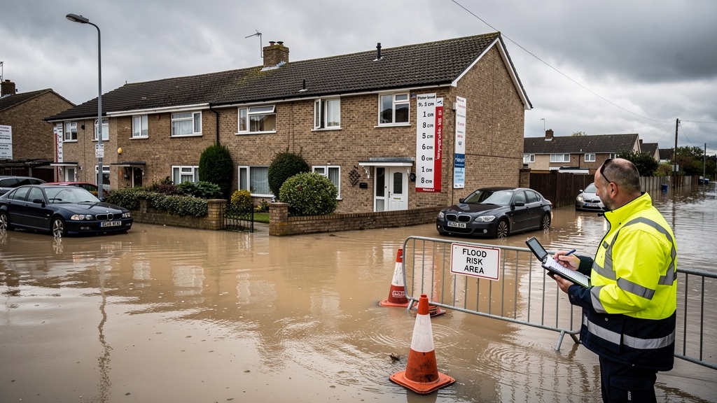
Flood risk is one of the most scrutinised aspects of the UK planning system — and rightly so. With climate change increasing the frequency and severity of flooding events across England and Wales, planning authorities and the Environment Agency are applying ever greater scrutiny to development proposals near watercourses, in low-lying areas and within formally designated flood risk zones.
If your site falls within or near a flood risk area, you will almost certainly need a Flood Risk Assessment (FRA) as part of your planning application. But here's the thing that many applicants — and even some planning consultants — don't fully appreciate: a flood risk assessment is only as good as the topographic data underpinning it. Get the survey wrong, and the entire FRA may be flawed.
In this article, I want to explain exactly why the topographic survey is the foundation of any credible flood risk assessment, what a flood risk survey needs to include, and why taking shortcuts with LiDAR data or OS maps is a risk that simply isn't worth taking.
What Is a Flood Risk Assessment?
A Flood Risk Assessment is a technical document that evaluates the flood risk to and from a proposed development site. It is required by the National Planning Policy Framework (NPPF) and associated Planning Practice Guidance (PPG) for:
- All development proposals in Flood Zone 2 or Flood Zone 3 (as defined by the Environment Agency)
- Development of 1 hectare or more in Flood Zone 1
- Any development within a Critical Drainage Area (as defined by the Lead Local Flood Authority)
- Development that may be affected by surface water flooding, groundwater flooding or other forms of flood risk
The FRA must demonstrate that the development will not be put at unacceptable flood risk, will not increase flood risk elsewhere, and incorporates appropriate flood risk mitigation measures where required. Local authorities will not validate a planning application in a flood risk zone without a satisfactory FRA.
Why Does the FRA Need an Accurate Topographic Survey?
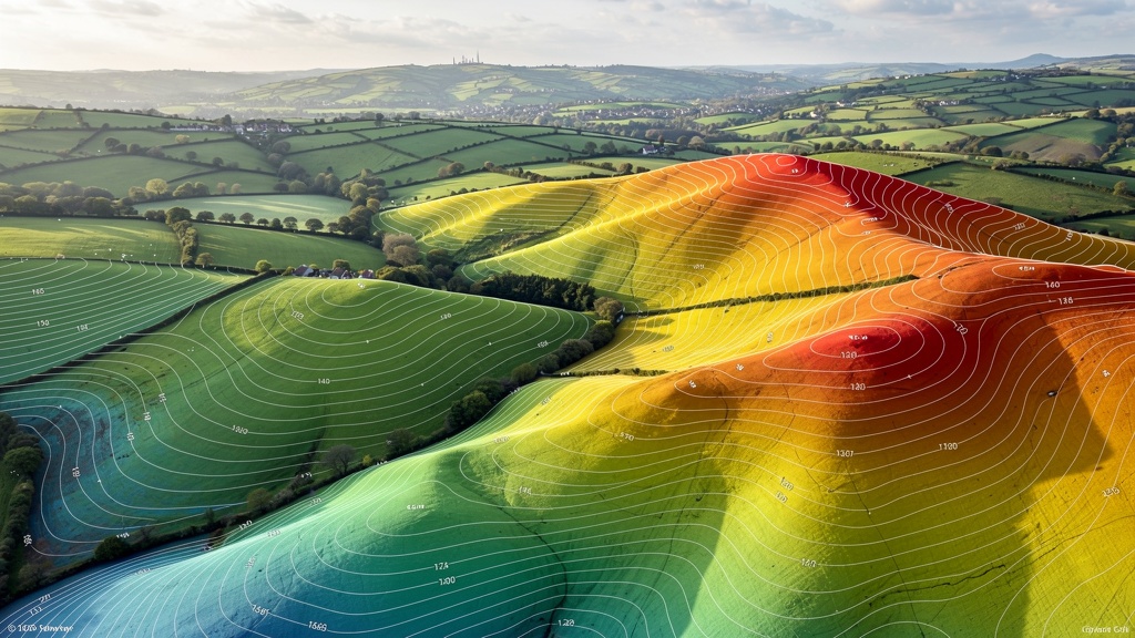
A flood risk assessment is fundamentally a hydrological and hydraulic analysis — a modelling exercise that simulates how water behaves across a landscape under various rainfall and river flow scenarios. At the heart of that modelling is topographic data: the precise shape and elevation of the ground surface.
Flood modelling software — whether HEC-RAS, TUFLOW, ISIS, Flood Modeller or any other package — uses topographic data to simulate how water flows across a landscape, where it ponds, what flow routes it takes and at what depths and velocities it travels. If the topographic data is inaccurate, the flood model is inaccurate. And if the flood model is inaccurate, the conclusions of the FRA — the recommended finished floor levels, the flood mitigation measures, the assessment of residual risk — may be fundamentally wrong.
I want to share a real example from our own project history. We were commissioned to carry out a topographic survey for a proposed residential development near a watercourse in Somerset. The developer had initially proposed to use Environment Agency LiDAR data as the basis for the flood model. When we carried out a ground-based survey, we found that the LiDAR data overstated ground levels at the critical point near the watercourse by approximately 0.4 metres — enough to put the proposed finished floor levels in potential jeopardy under the 1-in-100-year flood scenario. That seemingly small error would have resulted in either an inadequate FRA or, worse, buildings that weren't safely above the modelled flood level.
"A flood risk assessment is only as good as the topographic data beneath it. Errors of just a few centimetres can change the entire risk picture."
Understanding UK Flood Zones
To understand why topographic accuracy matters so much, it's helpful to understand how the UK flood zone system works.
Flood Zone 1: Low Probability
Land assessed as having less than a 1-in-1,000 annual probability of flooding from rivers or the sea. Most development is acceptable here, though larger sites may still require an FRA and surface water drainage strategy.
Flood Zone 2: Medium Probability
Land with between a 1-in-100 and 1-in-1,000 annual probability of river flooding, or between a 1-in-200 and 1-in-1,000 annual probability of sea flooding. An FRA is required for most development in this zone, and a Sequential Test must be passed.
Flood Zone 3a: High Probability
Land with a greater than 1-in-100 annual probability of river flooding or greater than 1-in-200 annual probability of sea flooding. Development in this zone faces the most stringent requirements. Highly vulnerable uses (such as dwellings) are only acceptable if an Exception Test is passed.
Flood Zone 3b: The Functional Floodplain
Land which currently floods or is designed to flood in an extreme event, or which has a 1-in-20 or greater annual probability of flooding. Only water-compatible development and essential infrastructure is acceptable here. For most purposes, building in Zone 3b is effectively prohibited.
The boundaries between these zones are defined using hydraulic modelling — modelling that is itself based on topographic data. The Environment Agency's flood zone maps are a useful screening tool, but they are national-scale models and may not accurately reflect conditions on a specific site. A site-specific topographic survey allows a hydrologist to produce a more refined, site-accurate flood model that may demonstrate lower risk than the EA's strategic model suggests — potentially unlocking development that the zone maps would otherwise preclude.
What Does a Flood Risk Topographic Survey Include?
A topographic survey commissioned specifically to support a flood risk assessment needs to be more comprehensive than a standard topo survey. The additional elements needed for flood risk purposes include:
Standard Topographic Elements
- Ground levels at sufficient density across the whole site and surrounding areas to accurately model surface water flow paths
- All built features — buildings, walls, fences, roads, paths — with levels
- Contour lines at appropriate intervals (typically 0.1m or 0.25m for sites with low relief)
- All levels referenced to Ordnance Survey Datum (Newlyn) — essential for relating survey data to EA flood map levels
Flood-Specific Survey Elements
- Watercourse cross-sections — measured at regular intervals (typically every 10–25m) along any watercourses on or adjacent to the site, capturing both the channel geometry and the floodplain topography on both banks
- Culvert positions and dimensions — culverts are critical flow constraints; both the position, orientation and internal dimensions (span, rise, soffit and invert levels) need to be surveyed accurately
- Drainage features — manhole positions, cover levels, invert levels, gullies, ditches, outfalls and their connecting pipe gradients and sizes where accessible
- Flood defence structures — positions, dimensions and crest levels of any embankments, flood walls, bunds or berms on or near the site
- Existing buildings — finished floor levels, threshold levels and ground floor window sill levels of any buildings within the potential flood extent, for consequence assessment purposes
- Bridge structures — soffit levels, deck levels and any features affecting the conveyance of floodwater
Can You Use Environment Agency LiDAR Instead of a Survey?
This is one of the most common questions we're asked by flood risk consultants and planning agents, and the answer requires some nuance.
The Environment Agency makes LiDAR data freely available through its Open Data portal. This data is generated from aerial surveys flown by the EA at regular intervals, and it covers most of England at 1m or 2m resolution. In recent years, 25cm and 50cm resolution composite datasets have become available in many areas. It is an invaluable national dataset.
However, for site-specific development proposals, EA LiDAR has significant limitations:
- Resolution — even at 50cm resolution, the data is insufficient for accurately modelling site-scale hydraulics, particularly where small features like culverts, drainage channels and bunds are critical flow constraints
- LiDAR cannot penetrate water, vegetation or buildings — creating data voids in precisely the areas where accuracy matters most. A watercourse obscured by riparian vegetation will not be captured accurately by aerial LiDAR.
- Currency — LiDAR surveys are not carried out continuously, and the data may be several years out of date. Earthworks, drainage improvements, new buildings and floodplain modifications may not be reflected.
- Vertical accuracy — the Environment Agency quotes a typical vertical accuracy of ±15cm RMSE for its LiDAR data. This is adequate for landscape-scale flood modelling but insufficient for setting finished floor levels or assessing freeboard against design flood levels.
- Culvert and drainage data — LiDAR cannot capture underground drainage features. Without measured culvert dimensions and invert levels, hydraulic models may significantly misrepresent flow capacity at critical constriction points.
For strategic-level flood risk screening — to determine whether a site is broadly in a low, medium or high flood risk zone — LiDAR data is perfectly appropriate. But for a site-specific FRA submitted to a local authority or the Environment Agency in support of a planning application, a ground-based topographic survey is essential. We work directly with flood risk consultants and hydrologists to ensure our survey data is in exactly the format their software requires.
The Sequential Test and Site Selection
An aspect of flood risk that is sometimes overlooked at the survey stage is the Sequential Test. Under the NPPF, local planning authorities must apply a sequential approach to site selection, directing development away from areas at highest flood risk wherever possible.
For applicants, this means demonstrating in the FRA that there are no reasonably available alternative sites at lower flood risk that could accommodate the proposed development. In practice, this often requires a review of the flood risk of alternative sites — and sometimes a rapid topographic survey of candidate sites to inform that comparison.
Getting the topographic evidence right at the Sequential Test stage can save months of delay later in the planning process.
Finished Floor Levels: Getting It Right
Perhaps the single most important output of a flood risk topographic survey — from the perspective of the development's occupants — is the determination of appropriate finished floor levels (FFLs). The FRA will recommend minimum FFLs based on the modelled flood levels, plus a freeboard allowance and a climate change uplift.
The starting point for this calculation is accurate ground levels on the site. If the topographic survey understates existing ground levels by even 100mm, the proposed FFL recommendation may be 100mm too low — putting future occupants at greater risk than the FRA claims.
At Surveyor Topographer, we take particular care with datum referencing — ensuring our survey levels are accurately tied to Ordnance Survey Datum (Newlyn), which is the datum used by the Environment Agency for all its flood level data. An FRA that uses a local or assumed datum rather than OS datum is likely to be challenged by the EA and may result in the application being refused or deferred pending re-survey.
Working With Your Flood Risk Consultant
The most efficient way to commission a flood risk topographic survey is to work in close coordination with your flood risk consultant (the hydrologist or drainage engineer who will be preparing the FRA). They will know exactly what data they need — which cross-sections, which drainage features, which level benchmarks — and can specify the survey requirements precisely.
We work regularly alongside flood risk consultants across the UK, and we're happy to liaise directly with your consultant to agree the survey specification before we attend site. This avoids the frustrating — and costly — situation of returning to site because a critical data point was missed on the first visit.
How Long Does a Flood Risk Topographic Survey Take?
The survey time will depend on the size and complexity of the site, and the extent of watercourse cross-sections required. As a rough guide:
- Small residential site (up to 0.5ha) with limited watercourse frontage — typically one day on site, drawings within five working days
- Medium development site (0.5–2ha) with significant watercourse frontage — typically one to two days on site, drawings within seven to ten working days
- Large or complex sites with extensive drainage survey requirements — two to four days on site, programme to be confirmed on quotation
All our flood risk surveys are delivered with a survey specification document confirming the datum, equipment, accuracy and methodology — the supporting documentation that your flood risk consultant will need for the FRA.
FAQ: Flood Risk Topographic Surveys
Not necessarily for proximity to water alone — but if your site is in Flood Zone 2 or 3 as shown on the Environment Agency's flood map, an FRA is required. Sites in Flood Zone 1 that are 1 hectare or more, or that are within a Critical Drainage Area, also require an FRA. Check the EA's Flood Map for Planning as a starting point, then seek advice from a flood risk consultant and your local planning authority.
Yes — in fact, combining the topographic survey with other site investigations (ground investigation, ecology surveys, etc.) is usually more efficient for the client in terms of site access arrangements and time. We're happy to coordinate with other consultants to share site visits wherever possible.
Datum is the reference level from which all height measurements are taken. In the UK, the standard datum is Ordnance Datum Newlyn (ODN) — the mean sea level at Newlyn, Cornwall, as measured in the early 20th century. All Environment Agency flood level data (flood zone boundaries, modelled flood levels, design flood levels) is expressed in metres above ODN. If your topographic survey uses a different datum — even an assumed local datum — it cannot be directly compared with EA flood data, and the FRA will be unreliable. All our surveys are referenced to ODN.
The Sequential Test is a requirement of national planning policy that directs new development to areas at lowest flood risk. If your site is in Flood Zone 2 or 3, or in a Critical Drainage Area, you will likely need to demonstrate that there are no suitable alternative sites at lower flood risk that could accommodate your development. Your flood risk consultant or planning consultant can advise on the specific requirements for your application.
The Environment Agency is a statutory consultee for planning applications in flood risk areas. If the EA objects to the FRA on grounds of inadequate topographic data or insufficient analysis, the planning application is likely to be refused or deferred. The most common reason for EA objections to FRAs is insufficient survey accuracy — particularly the use of LiDAR or OS data instead of a ground-based survey. Starting with a comprehensive, properly referenced topographic survey significantly reduces this risk.
A flood risk topographic survey typically costs more than a standard topo survey, reflecting the additional data collection required (watercourse cross-sections, culvert surveys, drainage feature levels). For a typical residential development site near a watercourse, expect to pay £1,200–£2,500 + VAT. Larger or more complex sites will cost more. We provide fixed-price quotes within 24 hours of receiving your site details — contact us to discuss your requirements.
Related Articles
Need a Flood Risk Topographic Survey?
Our team specialises in flood risk assessment surveys across the UK. Contact us for a free consultation and fixed-price quote.
Get a Free Quote