Construction and surveying are inseparable. From the first site investigation before planning, through to the final as-built record when the last brick is laid, surveys provide the precise spatial data that guides every stage of a construction project. Get the surveying right, and construction proceeds accurately and efficiently. Get it wrong, and the consequences range from minor inconvenience to structural failure.
At Surveyor Topographer, we support construction projects at every stage — from pre-design topographic surveys, through setting out and progress monitoring, to final as-built verification. In this guide, I want to explain the full range of construction survey work, what each type involves, and how good surveying practice protects both the quality of the construction and the interests of everyone involved.
The Role of Surveys in Construction
Construction surveying serves four broad purposes:
- Information gathering — capturing the existing site conditions accurately before design begins
- Setting out — translating the design from drawings into physical positions and levels on the ground
- Progress monitoring — measuring what has been built against what was designed
- Record keeping — producing as-built drawings that accurately record what has been constructed
Each of these functions requires different survey techniques and different levels of accuracy, but all share the same fundamental requirement: spatial data that accurately relates the construction to the design intent and to the real-world coordinate system.
Pre-Construction Topographic Surveys
The starting point for any construction project is a topographic survey of the site — a precise, comprehensive record of the existing ground conditions before any work begins. We cover this in detail in our guide to topographic surveys, but in the construction context, the topographic survey serves several specific functions:
Design Base
The topographic survey provides the base data from which architects and engineers develop their designs. Accurate ground levels are essential for calculating earthwork volumes, designing drainage gradients, setting finished floor levels and assessing the relationship between the proposed development and its surroundings.
Earthworks Planning
For any project involving significant earthworks — site levelling, cut-and-fill operations, embankment construction — the topographic survey provides the existing ground model that is compared with the proposed design model to calculate excavation and fill volumes. Accurate volume calculations are directly linked to cost — an error of 10% in the cut volume on a large project represents a significant contract sum.
Site Investigation Coordination
Geotechnical investigation (trial pits, boreholes) requires surveyed positions and levels so that ground investigation data can be related to design drawings. We regularly work alongside ground investigation contractors, surveying trial pit and borehole positions and levels as part of the pre-construction survey package.
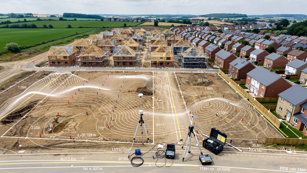
Construction Setting Out
Setting out is the process of translating the design from paper (or screen) to ground — marking the precise positions, levels and alignments where construction elements should be built. It is one of the most critical surveying functions in construction, because errors in setting out translate directly into errors in the built structure.
What Does Setting Out Involve?
Construction setting out typically involves:
- Establishing a site control network — a set of precisely surveyed control points, distributed across the site, from which all setting out work is referenced. The control network is tied to the OS national grid and datum.
- Setting out primary grids — marking the structural grid lines of the proposed building, from which all other positions are measured
- Foundation setting out — marking the precise positions of individual foundations, pile positions, ground beams and slab edges
- Level control — establishing and maintaining accurate level benchmarks across the site for controlling slab levels, drainage gradients and finished floor levels
- Ongoing setting out — as construction progresses, setting out requirements continue: column positions, stair positions, wall lines, service routes and so on
Accuracy Requirements for Setting Out
Setting out accuracy requirements vary depending on the type of construction:
- General civil and groundworks — typically ±25–50mm for earthworks, ±10–20mm for foundations
- Structural steelwork — typically ±5–10mm for column bases and anchor bolts
- Residential construction — typically ±10–25mm for foundation positions, ±5mm for level control
- Precision infrastructure — railway trackbeds, precast concrete assembly — may require ±1–5mm accuracy
Common Setting Out Errors and How to Avoid Them
Setting out errors are among the most costly mistakes in construction. Common causes include:
- Incorrect datum or grid reference — using a local assumed datum rather than OS datum, or transposing coordinates (eastings and northings)
- Insufficient control point density — control points too widely spaced, leading to accumulated errors over long distances
- Control point disturbance — temporary control markers disturbed by construction activity without detection
- Poor coordination between surveyor and contractor — unclear communication about what has been set out and what tolerances apply
The best protection against setting out errors is rigorous independent checking — verifying all set-out positions against the control network before construction proceeds. On larger projects, we routinely provide an independent check survey service, measuring completed setting out against design coordinates to detect any errors before they are built in.
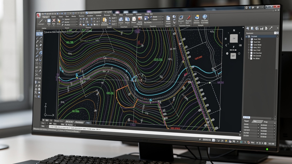
As-Built Surveys
An as-built survey (also called a record survey) documents the position and levels of what has actually been built, compared with the design drawings. As-built surveys serve several important purposes:
Quality Assurance
Comparing as-built measurements with design coordinates reveals any deviations from design intent before they cause problems at later construction stages. A foundation that is 50mm out of position may be acceptable. A foundation that is 200mm out of position — and has been built on — may require expensive remediation.
Underground Services Records
Drainage, water supply, electrical and telecoms services are buried during construction, making their positions invisible after backfilling. An as-built survey of all underground services — carried out before backfilling — creates a permanent record of their positions that is essential for future maintenance, extensions and avoiding damage during subsequent ground works.
Handover Documentation
At project completion, as-built drawings are a standard deliverable to the client — required by Building Regulations, often required by funders and lenders, and essential for future occupier management. An as-built topographic survey shows the final ground levels, drainage layout, finished floor levels, site boundaries and all hard landscaping elements as actually constructed.
Lease Plans and Land Registry
Where new buildings or subdivided properties are to be registered at the Land Registry, or where lease plans are required for new commercial lettings, as-built surveys provide the precise measurements from which these legal documents are produced.
Structural Monitoring Surveys
Construction activities can cause movement in adjacent structures — buildings, retaining walls, bridges, embankments. Structural monitoring surveys detect and quantify this movement, allowing engineers to manage the risk and respond if movement exceeds acceptable limits.
How Monitoring Works
Monitoring typically involves:
- Establishing a network of fixed reference points (datums) at a safe distance from the construction activity — points that are assumed to be stable throughout the monitoring period
- Installing monitoring prisms or targets on the structures or ground surfaces to be monitored
- Measuring the positions of all monitoring points at regular intervals (daily, weekly or at key construction stages, depending on the risk level)
- Comparing each measurement with the baseline to calculate movement in three dimensions
- Reporting movement against pre-agreed trigger and alarm levels
Applications of Construction Monitoring
- Deep excavations — piling, basement excavations and cofferdam construction near existing buildings
- Tunnelling and underground works — settlement monitoring of buildings and utilities above TBM drives and cut-and-cover works
- Demolition — monitoring of adjacent buildings during demolition of a structure that has been providing support
- Ground improvement — dynamic compaction, vibro-compaction and other ground treatment methods that can cause vibration and settlement
- Long-term structural monitoring — ongoing monitoring of bridges, retaining walls, dams and embankments over their service life
Earthworks Volume Surveys
On sites involving significant earthmoving — cut-and-fill for platform creation, road construction, quarrying, waste management — volumetric surveys are used to calculate the quantities of material moved. These calculations directly affect contract payments, waste disposal costs and environmental permits.
Volume surveys compare two surface models — typically a pre-construction topographic survey and a post-excavation or post-fill survey — to calculate the volume of material moved. Modern methods include:
- Ground-based GPS/total station — measuring a grid of levels across the site at both stages and calculating volumes from the difference
- Drone photogrammetry — particularly efficient for large earthwork areas, producing a digital surface model that is compared with the pre-construction model
- 3D laser scanning — for smaller sites, stockpiles and complex geometric volumes where high accuracy is required
Volume surveys are typically specified at ±2–5% accuracy, which is achievable with all three methods under good conditions.
Best Practice for Construction Surveying
Based on our experience supporting construction projects of all scales and types, here are the key principles of good construction surveying practice:
- Establish a robust site control network at the start — invest in a well-designed, well-observed control network from day one. All subsequent survey work depends on it.
- Protect control points — mark control points clearly, protect them from disturbance where possible, and carry out periodic checks on their stability throughout the project
- Maintain consistent datum referencing — always reference all surveys to the OS national grid and datum. Never introduce local or assumed datums that can't be related to external data.
- Document everything — a construction survey programme without clear record-keeping is not a programme at all. All setting out, as-built measurements and monitoring data should be recorded systematically and retained for the project lifetime.
- Coordinate with the design team — good surveying is not just a technical exercise; it requires close coordination with the design team, the contractor and the project manager to ensure the right data is available at the right time.
- Carry out independent checks — for critical elements (foundation positions, structure-to-boundary relationships, finished floor levels), independent checking of setting out before construction proceeds is an investment that pays for itself every time.
FAQ: Construction Surveys
Setting out is typically the contractor's responsibility. Many contractors have in-house setting out teams. However, for complex projects or where independent verification is required by the employer or funder, an independent survey contractor (such as ourselves) is engaged to verify or supplement the contractor's setting out. For some specialist setting out tasks — pile positions on congested sites, precision structural grid lines — independent surveyors are specifically engaged for the setting out work itself.
A site datum is a fixed, precisely levelled reference point from which all height measurements on the site are taken. On OS-referenced surveys, the site datum is connected to Ordnance Datum Newlyn (mean sea level at Newlyn). Using a consistent, OS-referenced datum throughout a project ensures that all survey measurements — design levels, setting out levels, as-built levels — are comparable and can be related to data from other sources (drainage records, flood maps, utility plans).
The frequency of structural monitoring depends on the risk level and the monitoring methodology. For high-risk situations (deep excavations adjacent to sensitive structures), automated monitoring may provide near-continuous data. For lower-risk situations, weekly or fortnightly visits by a survey team may be sufficient. The monitoring frequency and trigger levels are typically specified by the geotechnical or structural engineer as part of the project's monitoring and observational method requirements.
For most construction projects — particularly those involving new buildings, drainage works or ground-level changes — as-built drawings are required as part of the Building Regulations completion process and are expected as a project deliverable by most clients. They are also an essential reference for future maintenance, extensions and alterations. We recommend including as-built survey in the project programme from the outset, rather than trying to reconstruct the as-built record after the fact from site photographs and contractor's sketches.
A topographic survey records what exists — the current state of the site. A setting out survey creates what should be — it translates design coordinates into physical positions and levels on the ground. The two surveys are complementary and both use the same equipment and control network, but they serve opposite functions: one records reality, the other implements the design.
Related Articles
Need Surveying Support for Your Construction Project?
From pre-design topographic surveys to setting out and as-built records, our construction survey team supports projects of all scales across the UK.
Get a Free Quote