Professional land surveyor with total station equipment overlooking a sweeping UK countryside panorama at golden hour

UK-Wide Topographic Survey Coverage

Surveyor Topographer delivers precise land survey services across England, Scotland and Wales. No project is too remote — we'll travel to you.

47+ Counties Served
1,200+ Surveys Completed
5 Days Avg Mobilisation
3 Nations Covered
18+ Years Experience

Surveyor Topographer Covers the Whole of the UK

We are a UK-wide survey company, with teams based in the North, Midlands, South and Scotland. This means we can mobilise quickly to carry out your topographic survey wherever your site is — from the Highlands to the Home Counties.

Our core service areas cover 47 counties and major urban centres, but we genuinely cover the entire United Kingdom. If you're unsure whether we serve your area, just ask — we've never said no to a challenging location.

Travel costs are included transparently in all quotations. For most UK locations, there are no additional mobilisation fees.

Fast Response Guaranteed

We aim to mobilise within 5 working days for standard topographic surveys. Urgent requests handled by arrangement.

Detailed topographic survey map of UK countryside showing contour lines, elevation data and survey control points

Survey Coverage by Region

Browse our coverage by region. Don't see your area? Get in touch — we cover the full UK.

Manchester and Leeds city skyline, Northern England urban landscape with Victorian architecture and modern buildings at golden hour Northern England

Northern England

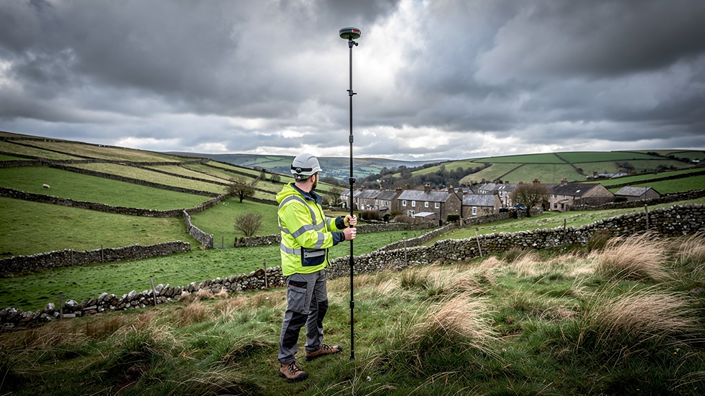
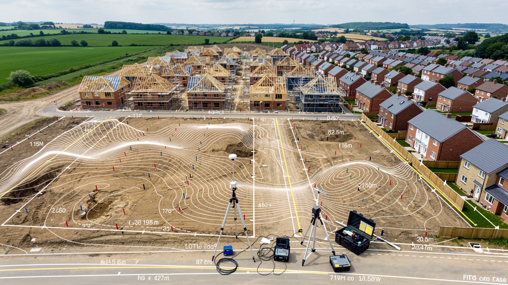
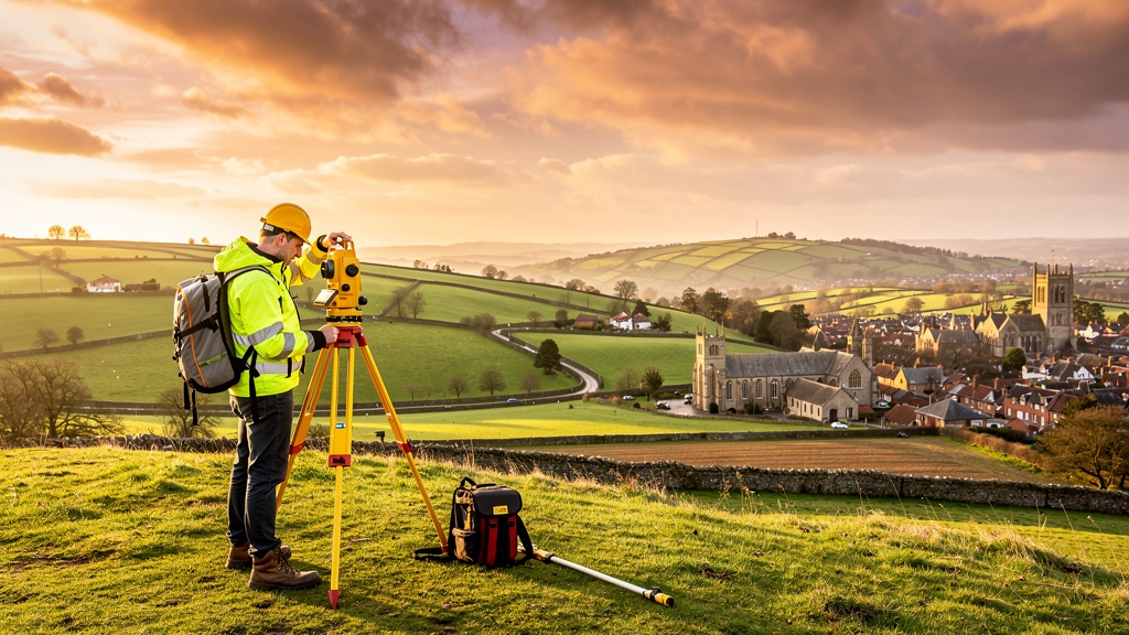
From the Peak District to the Pennines — our surveyors are on the ground across the North, covering major cities and rural communities alike.

ManchesterLiverpool LeedsSheffield NewcastleSunderland YorkHull CumbriaLancashire CheshireDurham North YorkshireNorthumberland
Birmingham city centre Midlands England skyline with canal network and modern commercial development at dusk Midlands

Midlands

The heart of England — covering Birmingham, the East Midlands and everything in between, from urban regeneration sites to agricultural land surveys.

BirminghamCoventry NottinghamLeicester DerbyStoke-on-Trent WolverhamptonWorcester ShropshireHerefordshire LincolnshireStaffordshire
London skyline with Tower Bridge and River Thames, iconic South East England cityscape on a clear blue day London & SE

London & South East

Dense urban environments, listed buildings, tight planning constraints — our London and South East team handles the most complex survey projects with precision.

LondonSurrey KentSussex HampshireEssex HertfordshireBerkshire OxfordshireBuckinghamshire BedfordshireSuffolk NorfolkCambridge
Bristol harbourside and Clifton Suspension Bridge, South West England cityscape with green hills on a sunny day South West

South West

From Bristol's regeneration zones to Cornwall's coastal properties — we understand the unique challenges of surveying in the South West, including flood plains and heritage sites.

BristolSomerset DevonCornwall DorsetWiltshire GloucestershireBath SwindonExeter
Cardiff Bay waterfront Wales, Senedd building and Millennium Centre reflecting in the bay on a clear day Wales

Wales

We operate across all of Wales — from Cardiff's urban developments to the mountains of Snowdonia and the Pembrokeshire coast. Bilingual service available on request.

CardiffSwansea NewportWrexham CarmarthenshirePembrokeshire GwyneddCeredigion PowysAnglesey
Edinburgh Castle on volcanic rock with Old Town and New Town architecture, Arthur's Seat in the background under dramatic Scottish sky Scotland

Scotland

From Edinburgh's historic centre to the remote Highlands and island sites — our Scottish survey team is experienced in challenging terrain and long-range mobilisation.

EdinburghGlasgow AberdeenDundee InvernessStirling PerthFife HighlandBorders

How We Serve Remote & Rural Survey Locations

Some of the most interesting — and important — topographic survey projects happen in remote locations. Flood plains, upland sites, coastal cliff edges, island properties. We've carried out topographical land surveys in all of them.

Our survey team carries lightweight, field-ready GPS equipment and total station instruments that work in challenging terrain without the need for existing infrastructure. Where mobile connectivity is limited, we use offline data collection methods and process everything back at base.

For very large rural areas, we can also deploy drone photogrammetry to supplement ground-based surveying — reducing time on site while maintaining the accuracy your project demands.

View Our Services Get a Quote
Land surveyor with GPS RTK pole on a remote UK rural hillside with green pastures, dry stone walls and a distant village

Need a Survey in Your Area? Let's Talk.

Tell us where your site is and what you need. We'll confirm coverage and provide a free quote within one working day.

  • UK-wide topographical survey services
  • Fast mobilisation — typically within 5 working days
  • Transparent pricing with no hidden travel costs
  • Covering England, Scotland & Wales
Surveyor overlooking a sweeping UK countryside panorama — representing nationwide topographic survey coverage

Request a Survey Quote