One of the questions I get most often from clients who want to understand how we work is: "What equipment do you use, and why?" It's a fair question — the choice of survey equipment has a direct bearing on the speed, accuracy and suitability of the resulting survey data. And understanding the difference between GPS and a total station helps clients understand why survey specifications vary from project to project.
Both GPS and total station instruments are used routinely in topographic surveys. But they work in fundamentally different ways, and each has strengths and limitations that make it more or less appropriate for different types of site and survey task. In this guide, I'll explain how each technology works, when each is most appropriate, and why — on most real-world sites — the best surveys use both.
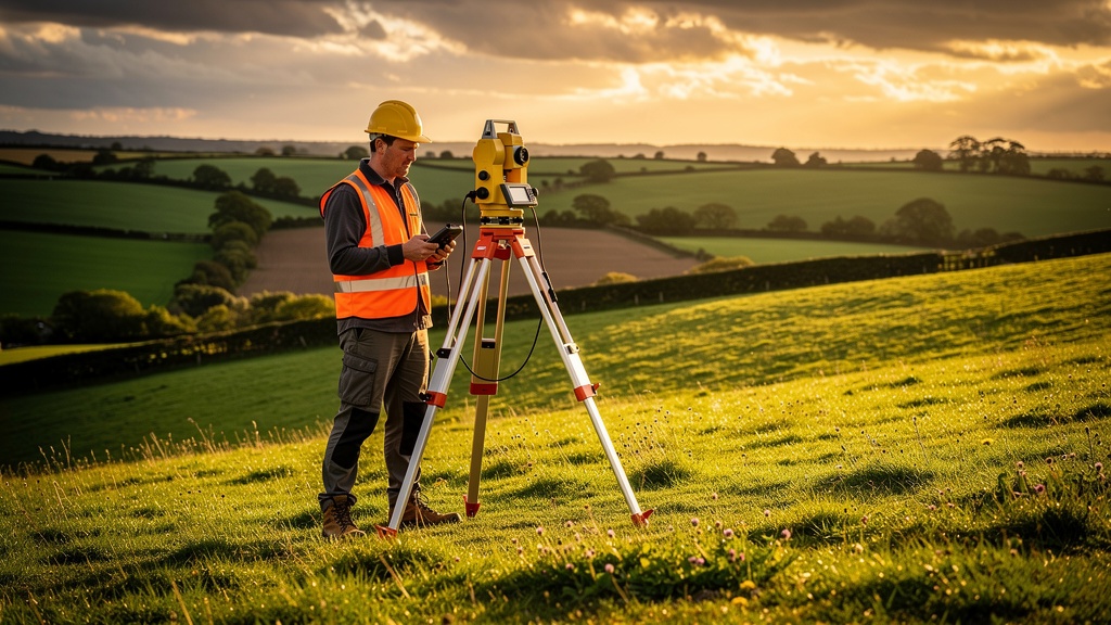
How GPS Works in Land Surveying
GPS (Global Positioning System) — more precisely, GNSS (Global Navigation Satellite System) in its modern multi-constellation form — uses signals from satellites orbiting the earth to calculate the position of a receiver on the ground. A survey-grade GNSS receiver can achieve positional accuracy of ±10–20mm horizontally and ±15–30mm vertically under good conditions — far more accurate than the GPS in your smartphone, which typically achieves only ±3–5 metres.
In surveying, we use a specific technique called RTK GPS (Real-Time Kinematic). RTK uses a fixed base station (either set up on site or connected to a network of continuously operating reference stations, such as the OS Net) to provide real-time corrections to the rover receiver carried by the surveyor. This dramatically improves accuracy to ±10mm horizontally and ±20mm vertically — sufficient for most topographic survey work.
The great advantage of RTK GPS is speed: a skilled surveyor with an RTK system can record dozens of points per hour across an open site, all directly referenced to the OS national grid and datum without the need for any prior site setup. For large, open sites with clear sky visibility, GPS is the fastest and most efficient tool available.
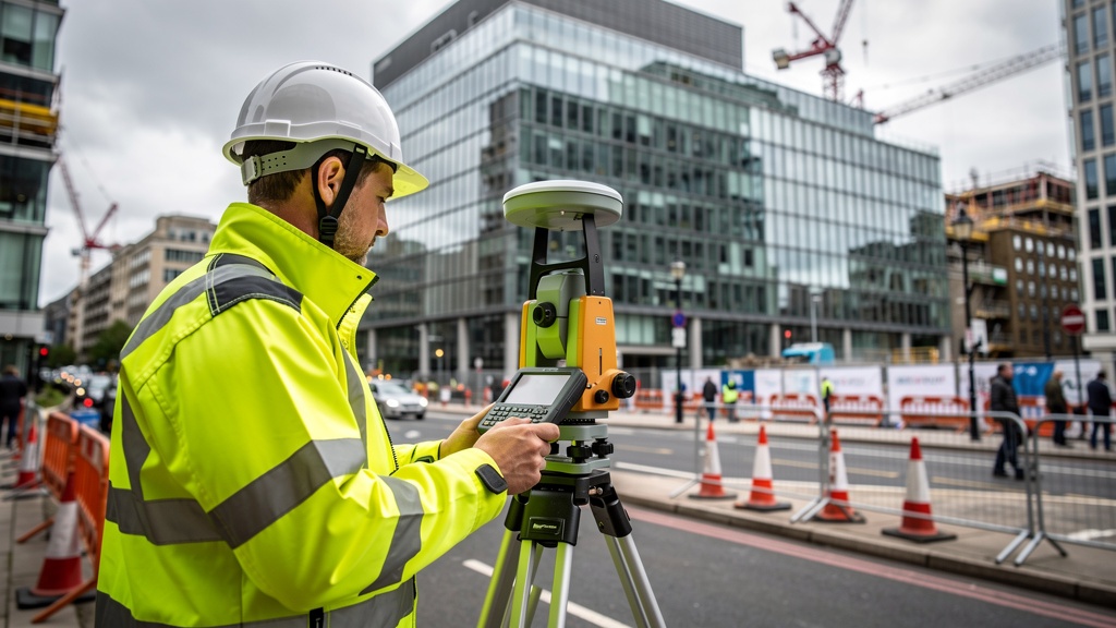
How a Total Station Works
A total station is an electronic surveying instrument that measures angles and distances using an internal electronic distance measurement (EDM) unit and precision angle encoders. It is set up on a tripod at a known position (a control point) and used to measure the direction and distance to a prism reflector held at each feature to be surveyed.
By combining the measured angle and distance with the known position and orientation of the instrument, the total station calculates the precise three-dimensional coordinates of each measured point. Modern total stations can achieve angular accuracy of 1–5 arc seconds and distance accuracy of ±2mm + 2ppm — extremely precise measurements that are essentially independent of sky visibility or satellite signal.
The key strength of the total station is that it works by direct geometric measurement, unaffected by satellite geometry, multipath errors or atmospheric effects. It performs reliably in conditions where GPS struggles — under dense tree canopy, in urban canyons, indoors, and in any environment where sky visibility is limited.
GPS Strengths and Limitations
Strengths of GPS for Topographic Surveys
- Speed on open sites — RTK GPS allows a single surveyor to record hundreds of points per day on open land, without the need to set up and orient multiple instrument stations
- Direct OS grid referencing — modern GNSS with OS Net corrections gives OS national grid coordinates directly, without the need for a traditional GPS network or benchmarks
- Single-person operation — RTK GPS can be operated by one surveyor, reducing costs on large, straightforward sites
- No line-of-sight requirement between instrument and prism — the surveyor can move freely around the site without maintaining visibility to a fixed instrument station
- Ideal for large agricultural and rural sites — where tree cover is minimal and sight lines are long
Limitations of GPS for Topographic Surveys
- Requires clear sky visibility — GPS signals are blocked or degraded by buildings, bridges, dense tree canopy and other overhead obstructions. In urban environments, tall buildings create "urban canyons" where GPS performance is poor.
- Multipath errors — signals reflected from buildings and other surfaces can introduce errors in GPS positioning. These are typically small but can be significant for precision work in built-up areas.
- Cannot work indoors — for measured building surveys and internal surveys, GPS is entirely unsuitable
- Vertical accuracy is inherently lower than horizontal — GPS height determination is less precise than horizontal positioning, which can be a limitation for surveys where accurate ground levels are critical
- Network dependency — RTK GPS using OS Net or a similar correction network requires mobile data connectivity. In remote areas with poor mobile coverage, a local base station must be set up.
Total Station Strengths and Limitations
Strengths of Total Station Surveys
- Works in any environment — indoors, underground, in dense woodland, in urban canyons, on sites with heavy machinery or overhead obstructions. As long as there is a line of sight from the instrument to the prism, a total station can measure.
- Consistent high accuracy — total station measurements are not affected by satellite geometry or atmospheric conditions. The same level of accuracy is achievable in a city centre as on an open hillside.
- Ideal for detail surveys of complex built environments — picking up individual features (manholes, kerb lines, building corners, drain gullies) with consistent sub-centimetre accuracy
- Essential for setting out — construction setting out (placing pegs and markers to guide construction) requires the direct geometric relationship that only a total station can provide reliably
- Works without mobile data — total station operation is entirely self-contained, with no dependency on mobile networks or external correction services
Limitations of Total Station Surveys
- Slower on large open sites — each measurement requires a prism holder to walk to the feature and hold the prism while the instrument operator records the measurement. On large sites, this is slower than GPS.
- Requires two operators for most work — a total station survey typically requires an instrument operator and a prism holder, which increases cost relative to single-operator GPS surveys on open ground
- Line-of-sight limitation — the total station must have an unobstructed line of sight to the prism. In dense vegetation or very cluttered environments, additional instrument setups may be required.
- Requires established control — the total station must be set up over a known control point (or a point established by GPS). This means GPS control points are typically required as the starting point for total station work.
Why Most Surveys Use Both GPS and Total Station
In professional surveying practice, GPS and total station are not competing technologies — they are complementary. The vast majority of our topographic surveys use both:
- GPS establishes the control framework — a small number of precisely measured GPS control points, distributed across the site, define the reference coordinate system for the whole survey. This ties the survey into the OS national grid and datum.
- Total station does the detail work — set up on the GPS control points, the total station is used to pick up all the individual features across the site: building corners, manholes, kerbs, boundaries, drainage channels. In areas with good sky visibility, GPS may also be used to supplement total station detail survey.
- The combination gives the best of both — the speed and direct OS-referencing of GPS, combined with the reliability and precision of total station measurement in every environment.
For very large, open rural sites, GPS may be the primary measurement tool throughout. For dense urban sites, heavily wooded sites or sites requiring a measured building survey, total station measurement dominates. For most mixed sites — a typical residential development, a brownfield site, a farm with a mixture of open fields and buildings — both are used.
What About Robotic Total Stations?
Modern robotic total stations can automatically track a prism carried by a single surveyor, eliminating the need for a second operator. The surveyor carries the prism pole and a handheld controller, and the instrument automatically follows and measures as they move around the site. This gives the efficiency advantage of single-operator GPS, combined with the precision and environmental reliability of total station measurement.
Robotic total stations have transformed field productivity for many types of survey work, and we use them routinely on sites where a conventional two-person total station survey would be unnecessarily slow or costly. They are particularly well-suited to complex urban sites where GPS is unreliable but rapid, single-operator data collection is required.
The Role of GPS in Remote Areas
For rural and remote sites — where mobile connectivity may be limited and OS Net RTK corrections are unavailable — we use post-processed GNSS (PGNSS) techniques. Instead of processing corrections in real time, the raw GNSS data is recorded and processed back in the office against data from the nearest Continuously Operating Reference Station (CORS). This achieves comparable accuracy to RTK, without dependency on real-time data connections.
For extremely remote sites — island properties, upland sites, sites in Scotland's more isolated regions — our surveyors carry portable base stations that can be used to establish local RTK corrections without any mobile data requirement at all.
Accuracy Comparison: GPS vs Total Station
Both technologies, used correctly, achieve accuracy well within the requirements of most topographic survey specifications. Here's a practical comparison:
- RTK GPS horizontal accuracy — typically ±10–20mm (1 sigma) under good conditions
- RTK GPS vertical accuracy — typically ±20–30mm (1 sigma)
- Total station angular accuracy — typically ±1–5mm at 50m range, depending on instrument grade
- Total station distance accuracy — typically ±2–5mm regardless of range
- Typical topographic survey specification — ±50mm horizontal, ±25mm vertical: comfortably achieved by both technologies under normal conditions
- High-accuracy survey specification — ±10mm horizontal, ±10mm vertical: achievable with total station; requires careful GPS technique and favourable conditions
FAQ: GPS and Total Station Surveys
What matters to you is the accuracy and completeness of the resulting survey data. The equipment used is the surveyor's professional choice — a competent surveyor will select the appropriate tools for your site and will use both GPS and total station where the site conditions require it. What you should specify (or ask about) is the accuracy standard for the survey, the datum and grid reference system, and the deliverable formats.
Modern RTK GPS can achieve setting out accuracy adequate for many construction tasks — particularly on open sites. However, for high-precision setting out (structural grids, foundation positions, column bases) a total station is generally preferred for its superior consistency and independence from satellite conditions. Many construction setting out tasks use GPS to establish primary control points, with the total station doing the precision detail work.
OS Net is the Ordnance Survey's network of continuously operating GNSS reference stations across Great Britain. By subscribing to OS Net and receiving real-time corrections from the nearest reference stations, survey-grade GNSS receivers can achieve centimetre-level accuracy directly in the OS national coordinate system, without the need to set up a local base station. We use OS Net corrections on the vast majority of our surveys across England, Scotland and Wales.
In construction, total stations are used for both as-built surveys (recording what has been built) and setting out (marking where things should be built). Setting out tasks include marking foundation positions, column grid lines, slab levels, pile positions and any other critical dimensional control needed by the construction team. Total stations are also used for structural monitoring — repeatedly measuring the position of specific points on a structure to detect movement over time.
GPS (Global Positioning System) refers specifically to the US-operated satellite navigation system. GNSS (Global Navigation Satellite System) is the generic term that encompasses all satellite navigation systems, including GPS, Europe's Galileo, Russia's GLONASS and China's BeiDou. Modern survey receivers use signals from multiple constellations simultaneously — this is why we refer to them as GNSS receivers rather than GPS receivers. Multi-constellation operation significantly improves accuracy, availability and reliability, particularly in challenging environments.
The required accuracy depends on the purpose of the survey. For most planning applications and architectural design work, a horizontal accuracy of ±50mm and vertical accuracy of ±25mm is standard and sufficient. For engineering design, structural setting out or precision monitoring, tighter tolerances (±10–20mm) are often specified. For flood risk surveys, vertical accuracy of ±25mm or better is typically required for reliable hydraulic modelling. We'll always discuss accuracy requirements with you when specifying the survey.
Related Articles
Ready to Commission Your Survey?
Our team uses the latest GPS, total station and 3D laser scanning equipment to deliver accurate, reliable survey data. Get a free quote today.
Get a Free Quote