Drone surveying — more formally, Unmanned Aerial Vehicle (UAV) photogrammetry or LiDAR — has attracted enormous attention in the surveying industry over the last five years. The technology has become more accessible, more accurate and more widely used, and it's now part of the toolkit for many surveying projects that would previously have been carried out entirely on foot.
But drone surveys are not a universal solution. They have specific strengths, specific limitations, and specific use cases where they add real value — and other situations where a conventional ground-based survey is still the better choice. Understanding the difference matters, because choosing the wrong method for your project wastes money and can produce data that doesn't meet your needs.
In this guide, I'll explain honestly how drone surveys work, what they're good for, where they fall short, and how we decide which approach — or which combination — is right for any given project.
What Is a Drone Survey?
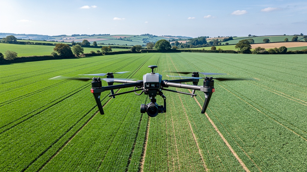
A drone survey uses an unmanned aerial vehicle (UAV) carrying either a camera (for photogrammetry) or a LiDAR sensor to capture data from above the site. The two main methods are:
Drone Photogrammetry
The drone flies a planned grid pattern over the site, capturing overlapping photographs at regular intervals. Specialist software (such as Agisoft Metashape or Pix4D) processes the overlapping images to produce:
- A dense point cloud of the survey area
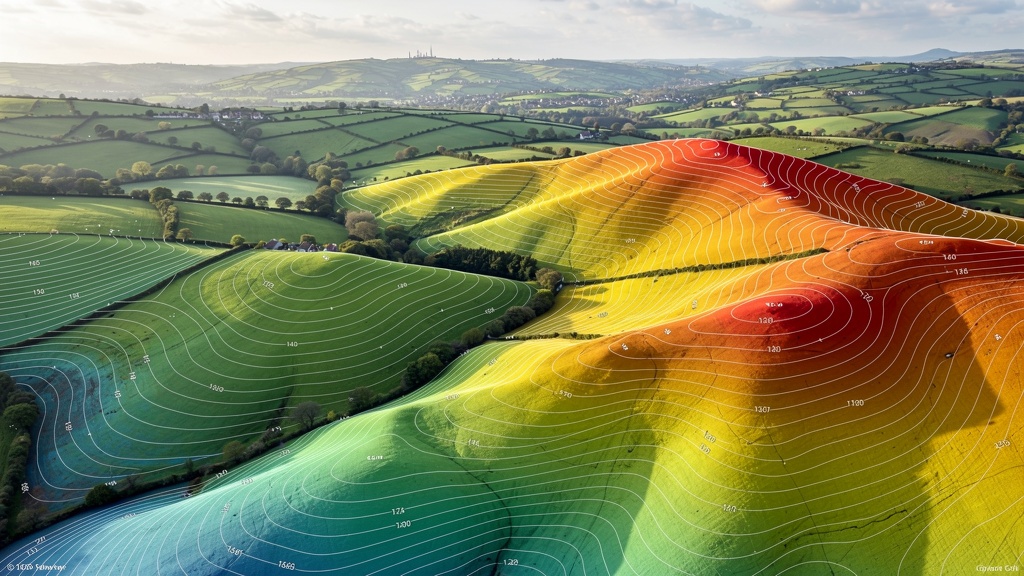
- A digital elevation model (DEM) — a grid of height values representing the ground surface
- An orthophoto — a geometrically corrected, plan-view photographic image of the site, accurate to the same standard as the survey
The key to accuracy in drone photogrammetry is the use of ground control points (GCPs) — physical targets placed across the site and precisely surveyed with GPS. GCPs allow the photogrammetric model to be scaled, oriented and positioned to the OS national grid and datum.
Drone LiDAR
Instead of a camera, the drone carries a miniaturised LiDAR (Light Detection and Ranging) sensor that fires laser pulses toward the ground and measures the return time. Drone LiDAR can capture several hundred thousand points per second, producing a dense point cloud similar to a terrestrial laser scan but captured from above.
The key advantage of drone LiDAR over photogrammetry is its ability to penetrate vegetation: laser pulses can pass through gaps in tree canopy to capture the ground surface beneath, whereas photogrammetry (being image-based) captures only the visible surface — which in vegetated areas means the top of the canopy, not the ground.
The Advantages of Drone Surveys
Drone surveying has genuinely transformed the speed and cost of surveying for certain types of site and project:
Speed Over Large Areas
A drone can cover 50–200 hectares in a single day's flying — far more than a ground survey team could cover on foot in the same time. For large agricultural land, large brownfield sites, infrastructure corridors and quarries, drone photogrammetry dramatically reduces survey time and cost.
Access to Difficult or Hazardous Areas
Steep slopes, unstable ground, contaminated land, live quarry faces, coastal cliffs — areas that would be dangerous or impossible to access on foot can be surveyed safely from the air. The drone operator works from safe ground while the drone captures data from above the hazard.
Comprehensive Visual Record
The orthophoto produced by drone photogrammetry provides a highly detailed, current aerial image of the site that can be used for planning, monitoring, stakeholder presentations and project management — in addition to the survey data.
Frequent Updates and Progress Monitoring
Drone surveys are quick and relatively inexpensive per hectare, making them ideal for regular progress monitoring on construction sites. A monthly drone survey of a development site allows project managers to track earthwork volumes, progress against programme and any deviations from design.
Volume Calculations
For quarrying, aggregate stockpiles, landfill sites and earthworks, drone surveys can calculate volumes with impressive accuracy — typically ±0.5–2% of the true volume — at a fraction of the cost of traditional ground-based volumetric surveys.
The Limitations of Drone Surveys
Despite their advantages, drone surveys have important limitations that make them unsuitable for certain types of work:
Cannot Survey Underground Features
Drains, manholes, culverts, utility covers and underground services are invisible from the air. A drone survey cannot capture the drain positions, manhole covers, invert levels and utility infrastructure that a planning application or engineering design typically requires. For any project where drainage data is needed, drone surveys must be supplemented with ground-based work.
Vegetation Penetration (Photogrammetry)
Drone photogrammetry captures the visible surface — which in areas of vegetation means the top of the canopy, not the ground beneath. For sites with significant tree cover, photogrammetry will overstate ground levels by the height of the vegetation. Drone LiDAR can penetrate sparse vegetation, but even LiDAR struggles to capture ground levels under dense, multi-layer woodland.
Minimum Contour Interval Limitations
The typical vertical accuracy of drone photogrammetry (±25–50mm) means contour intervals of less than 0.5m are not reliably achieved across a full site. For sites with very subtle level variation — flood plains, sites where drainage gradients of <1% are critical — ground-based survey provides more reliable vertical accuracy.
Regulatory Requirements
Drone operations in the UK are regulated by the Civil Aviation Authority (CAA) under the UK Drone Code. Flying in certain areas — near airports, in controlled airspace, above 400ft — requires CAA permissions. Urban areas often have complex airspace restrictions. Our drone operators hold CAA flyer and operator IDs and carry out pre-flight airspace assessments for every survey, but in some locations drone operations are simply not possible.
Weather Dependency
Drone surveys require reasonably good weather — rain and strong winds ground the aircraft. In the UK, where weather can be unpredictable, this can introduce scheduling uncertainty. Ground-based surveys are far less weather-dependent.
Feature Capture Quality
A drone survey captures what it can see from above. It cannot pick up the wall thickness of a boundary fence, the rebated face of a kerb, the underside of a bridge or any feature not visible from overhead. The level of feature detail in a drone survey product is significantly lower than in a ground-based total station survey.
When to Choose Drone Survey
Drone surveys are most valuable in these scenarios:
- Large open sites (5+ hectares) where ground-based survey would take multiple days and where drone coverage is the most cost-effective approach
- Quarries, aggregate stockpiles and landfill sites where volume calculations are the primary requirement
- Construction progress monitoring where regular updates of earthwork progress and volume calculations are needed
- Hazardous site access where steep slopes, contaminated ground or unstable surfaces make ground access dangerous
- Corridor surveys — pipelines, railway alignments, roads — where the linear nature of the site makes ground-based coverage inefficient
- Heritage site documentation where a bird's eye view and orthophoto are required for recording purposes
- Supplementary data for large development sites where the drone provides efficient coverage of the open areas while ground-based survey handles the detailed feature work near buildings and drainage
When to Choose Ground Survey
Ground-based surveys remain the better choice in these situations:
- Urban and suburban sites where GPS/drone is restricted by airspace, buildings and vegetation, and detailed feature capture (manholes, kerbs, drainage, boundaries) is critical
- Planning applications where a comprehensive feature survey — including all drainage, boundaries, trees and services — is required to planning specification
- Sites with dense vegetation where ground levels beneath tree canopy cannot be reliably captured by drone
- Flood risk surveys where watercourse cross-sections, culvert dimensions and drain levels need to be captured on the ground
- Measured building surveys — entirely ground-based (or laser scanning-based) by definition
- Small sites (under 2 hectares) where the mobilisation cost of a drone survey is not justified by the efficiency saving
The Combined Approach: Drone + Ground
For many large development projects, the optimal solution is a combination of drone and ground survey — using each method where it adds the most value:
- Drone photogrammetry covers the open areas of the site efficiently, producing a digital elevation model and orthophoto
- Ground survey (GPS + total station) supplements the drone data with detailed feature capture — manholes, drainage, kerbs, boundaries, trees — and ground control point surveys that tie the drone data into the OS national grid and datum
- The combined dataset is integrated in the office to produce a comprehensive topographic survey meeting full planning specification
This combined approach is often more cost-effective than a pure ground survey on sites above 5–10 hectares, while delivering the detailed feature data that a pure drone survey cannot provide.
Accuracy: How Do Drone and Ground Surveys Compare?
With proper ground control, drone photogrammetry can achieve horizontal accuracy of ±20–30mm and vertical accuracy of ±30–50mm. Drone LiDAR typically achieves ±50–100mm. Ground-based GPS survey achieves ±10–20mm horizontal and ±20–30mm vertical. Total station achieves ±5–10mm in both axes.
For most planning and development purposes, drone photogrammetry is sufficiently accurate. For high-precision work — engineering design, structural monitoring, flood risk surveying — ground-based methods remain more reliable.
FAQ: Drone Surveys vs Ground Surveys
Our drone operators hold CAA flyer and operator IDs, which cover standard commercial drone operations. For flights near aerodromes, in controlled airspace or in other restricted areas, additional permissions may be required from the CAA or the relevant airspace authority. We carry out a full pre-flight airspace and risk assessment for every drone survey and deal with all regulatory compliance — you don't need to do anything.
Yes, provided it is supplemented with appropriate ground-based data for features that the drone cannot capture (drainage, manholes, detailed boundary positions). The combined dataset is delivered as a standard topographic survey CAD file, indistinguishable in format from a purely ground-based survey. The survey specification document confirms the methods and accuracy, which is what planning authorities and engineers need to assess the data quality.
As a rough guide, drone surveys start to become cost-effective compared to ground surveys at around 3–5 hectares for reasonably open, unobstructed sites. For smaller sites, the mobilisation cost of drone equipment and post-processing time often makes it no cheaper than a ground survey. For large sites (10+ hectares), drone surveys are almost always more efficient and cost-effective than an equivalent ground survey.
No — drone surveys capture surface features only. Underground pipes, cables and services are invisible from the air. For projects where the underground services layout is important, we recommend a CAT (Cable Avoidance Tool) and Genny scan by a specialist utilities surveying company, in addition to the topographic survey. We can advise on and coordinate this if required.
Standard drone survey deliverables include: a dense point cloud (LAS/LAZ format), a digital elevation model (GeoTIFF), an orthophoto (GeoTIFF) and a topographic survey CAD drawing (DWG and PDF) including contour lines and all captured features. Where drone data is combined with ground-based data, the deliverables are integrated into a single comprehensive topographic survey package.
Related Articles
Not Sure Which Survey Method You Need?
Get in touch and we'll advise on the most appropriate approach for your site and project. All advice is free and without obligation.
Get a Free Quote